Tuesday
oregon

36. the dune coast & Port.

We rolled 101 through the redwood national park into the beaver state. We followed the coast peeking the vistas, walking the beaches, and camping windy sea sand dunes in the nights. After 3 days, escape from the cold coastal winds lured us east on highway 18 into the farmland light hills of western Oregon. After the $5 purchase of a goat skull at a roadside folding table, we made Portland.


We met up with friends, stayed 3 nights, saw the sights, then followed the Columbia east out of the city.


Leaving Portland on 84 east made a mental knot, planted a pocket of realization in my stomach that the trip would roll to a halt sooner rather than later, that we were heading homeward.

california coast

35. Up the Coast and Out of California

In 2001, Keil and I rode a jetplane from Indiana to Tuscon, then drove a two-door ford ranger, to the coast, up the Highway 1, from la to san. fran. We road in the bed, atop a futon mattress, luggage and a spare tire. Two of our girlfriends rode in the cab. We pulled a tarp over our heads when the girls in the cab knocked the knock that said: "a cop, get down." 8 years later, we pick up where we'd left it, San Fran up to the coastal redwoods of highway 101 up to portland.


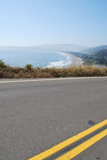
The Point Reyes National Seashore was inland, green and rolling, inter-coastal waterways, small towns, "BBQ", "Oysters", fishing boats, and salty docks. Thereafter, Highway 1 held tight to the coastline. The papery barked sweet funk of the coastal eucalyptus dissolved to fresh pine forest and rocky coastline, we camped a few nights on the slapping shore. Highway-1 ended south of Eureka, in Humbolt County, 1 became 101 or the "redwood highway".


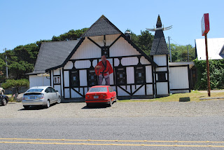
We stopped in on Redwood National Park and a few touristy hubs in the redwoods. I even paid $5 cash to drive my auto right through the pith of a monster.


It seems as soon as humans created autos, they decided they'd like to drive them through trees. This hole was gouged out in the 1930s. The tunnel tree back in Yosemite was driven through way back, before the turn of the century, in the late 1800s.

The end of California. After 15 days, and much experience, it feels pleasant to leave the state for Oregon. The lines on the map that mark the manifested edges of land bodies seem to change everything. Makes me want to howl and my truck needs to toot. Progress beats stagnation?

State stats:
The capital is Sacramento. CA is the 31st state to become official. It became so on the day of my birth in 1850, September the 9th, 132 years before I became official.
As size goes, CA is the 3rd largest state, next to Alaska & Texas. The highest point, as I've previously mentioned, is the top of Mt. Whitney at 14,495 feet above sea level. The lowest point, King's Canyon, at 282 ft. below sea level, is the lowest point in all the western hemisphere. Mt. Whit. and K. Canyon neighbor each other, they live in the same national park--Sequioa-Kings Canyon National Park. They say early Spanish explorers thought California was an island, so they named it after a queen, "Califia", who ruled an island in a Medieval romance story.
People, called Californians, call it The Golden State. Their song: "I Love You, California," Their motto: "Eureka, I have found it." Their tree is the redwood, their animal, the desert tortoise.
We'll leave it at that.
Monday
bay area model


34. the bay model

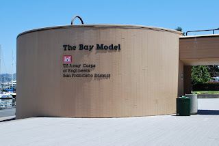
The San Fran. bay is the largest estuary of all the North American west coast and just over the red bridge, in Sausalito, the army core of engineers have created a working scale hydraulic-model of the bay, the rivers flowing in, and the big salty "peaceful sea." The model is of concrete and paint, plaster and steel, pipes and water. One can walk about the 2-acre bay-model-warehouse past the San Pablo Bay, the South Bay, the Pacific Ocean, the Suisun Bay, Honker Bay, and a portion of the Sacremento-Sanjoaquin River delta.

Continual battles over water rights, salinity and waste, between industry, farmers, fishes and flocks create quite a fragile and malleable environment in both the Bay and Central Valley. The hydraulic model was constructed in the 50s with hopes to arrive at the most bountiful decisions for all the Bay. The model simulates currents and tides. It has tested dredging channels, salt water intrusion into the delta, and has simulated the dispersal of treated waste-water.

The Central Valley of California is 400 miles long, much like "the size of Tennessee," as they say. Most of the area at one time was seasonal wetland, with flat open spaces, woodlands, and a thriving natural environment.
When the gold rush brought in the modern humans, when the gold was exhausted, the migrants turned to farming. These farmers built the first levees of the valley, diverting water to their pleasure and sowing their crops on the freshly manifested highgrounds.
People began calling these plots "islands of agriculture." Today the valley is loaded with reservoirs, canals, pumping plants, and aquaducts. Before the humans, even the great bear that is the CA state symbol, the grizzly, walked these lands.

In most instances, river deltas, the fingery sediment landforms at the mouths of rivers, form where the river meets the sea. In the water sheds of California, the delta forms inland where the major rivers of the Central Valley merge near Sacramento, CA. The Sacramento River flows from the north, and the San Joaquin flows from the south.


Friday
San Francisco

32. more pudgy yellow lands on into San Fran.

Reservoirs with house boat floats and water recreation.
bright blue canals winding into the central valley of lush.

windmills and ATVs, power towers, fruit stands. 1 pound strawberries for $2, 8 oranges for $3, peaches for $2, try before you buy, juices dripping to the dust.


the shipyards of Oakland, bright cargo crates sealed and stacked, barges in the bay, sailboats, fog. bay bridge, treasure island, frisco.

We climbed the high hills near the Golden G park.
Fancey houses and people, dogs, joggers and sweet smelling eucalyptus.
We stayed days roaming galleries shops steets and spending the nights at a friend's apartment on Divisidero.

The final morning, with brushed teeth & fresh socks, we headed out over the big red bridge.


Subscribe to:
Posts (Atom)
